Here’s some things I learned about today. Kinda rough, but whatever. I’ve been thinking for a while about jotting down at the end of the day a list of things I learned that day, and hey, might as well publish it!
Finger counting
Hat tip to @cbarrett for alerting me to the fact that counting on your fingers in Chinese involves flipping sweet gang signs.
Apparently the signs vary by region as well, in Guangdong/Hong Kong the signs for 7 and 8 are swapped (and in Malaysia the sign for 7 means 5). In Japan, folks fold fingers down rather than up. So four fingers held up and the thumb folded down means 1, then you fold your index finger down to mean 2, etc.

Lemma
I’d only known the word lemma to mean an intermediate proof, some smaller thing you needed to prove first before you could prove your main point. But it has a totally different meaning in linguistics! In linguistics, a lemma is a canonical form of a word, like you’d look up in a dictionary. So “climb” is the lemma that encompasses “climbing”, “climbs”, “climbed”, “climbers”, etc.
Of course, there are plenty of words that have the same lemma but different meanings. Like “lemma”, for example. And pretty much every common word can take on subtly different meanings depending on the context it’s used in. I had a, well, a long discussion with my Linguistics 101 teacher wherein I claimed that there was no such thing as a synonym, since saying the same thing in a different way means something subtly different. “Rubber band” and “elastic band” refer to the more or less the same set of things, but “elastic band” sounds a bit more formal or technical. So it has a subtly different meaning, I think. We ended up settling on separating denotational meaning and connotational meaning, though I’m sure there’s extensive study on the subject. What is that field called? Semantics, perhaps?
Procedurally generated cities
This morning I worked a little on my procedural city generation project, and found this really cool and simple explanation of some techniques by @phiresky (via the very-occasionally-interesting /r/proceduralgeneration). They made a great presentation and a neat demo explaining the stuff really well.
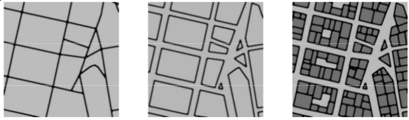
The method they described for laying out cities and connections at a higher level didn’t really satisfy me, though. The highways it produced seemed meandering and illogical, and too curvy, compared with examples from reality.
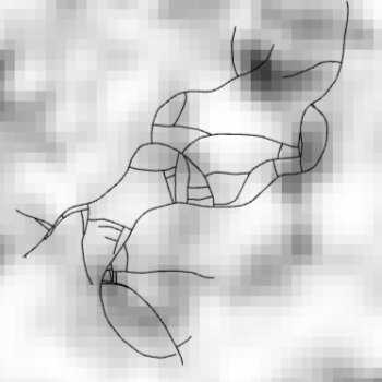
I decided to play around a bit with a different, slightly more teleological method. I distribute some “points of interest”, perhaps to become cities, perhaps just intersections, around a space. Then, I pick a source and destination for a “trip”, like someone wants to go from A to B. I look for a path of roads from A to B, and if there isn’t one, I create roads along the shortest path through the Delaunay linkages of the POIs, kind of simulating the traveler laying down a road as they go. If there is a path through existing roads, it might be too long to be considered a reasonable route, and in that case I go ahead with laying down new roads along the shortest path through the Delaunay linkages just as if there wasn’t a path at all. Otherwise the traveler just takes the existing path.
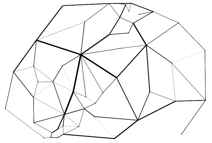
This is still pretty unsatisfying as a model of a realistic transport network, but it has some properties I like. The skeletal quality of the main roads is pretty neat, and it’s interesting that they don’t quite form a spanning tree—there are multiple networks of thick roads joined by thinner ones, though there’s still a rough hierarchy.
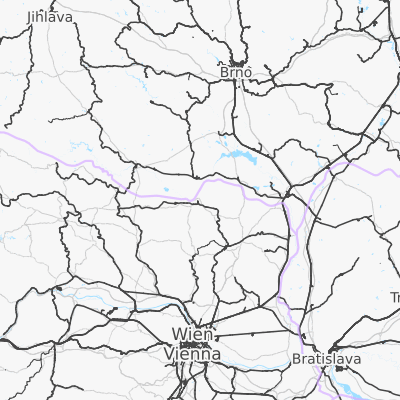
There are some things I’d like to improve on this model, for example, joining two nearby parallel highways together with an intersection if they get too close, and improving the method for placing new roads, but I think there’s not a whole lot closer this method can get to verisimilitudinous roads without a good notion of the underlying terrain. Roads track natural features a lot of the time (which is why they’re so straight in the US—there aren’t any natural features). Without some idea of what the gradients of the landscape are, there’s not much to hang a simulation on.
There’s tons more stuff in that presentation though, and a whole heap of references to follow up on, too. Got lots to chew on!